Middle Earth: How to create a Climate System from nothing
I didn’t want to invent the weather, so I took a whole year of it from 1950.
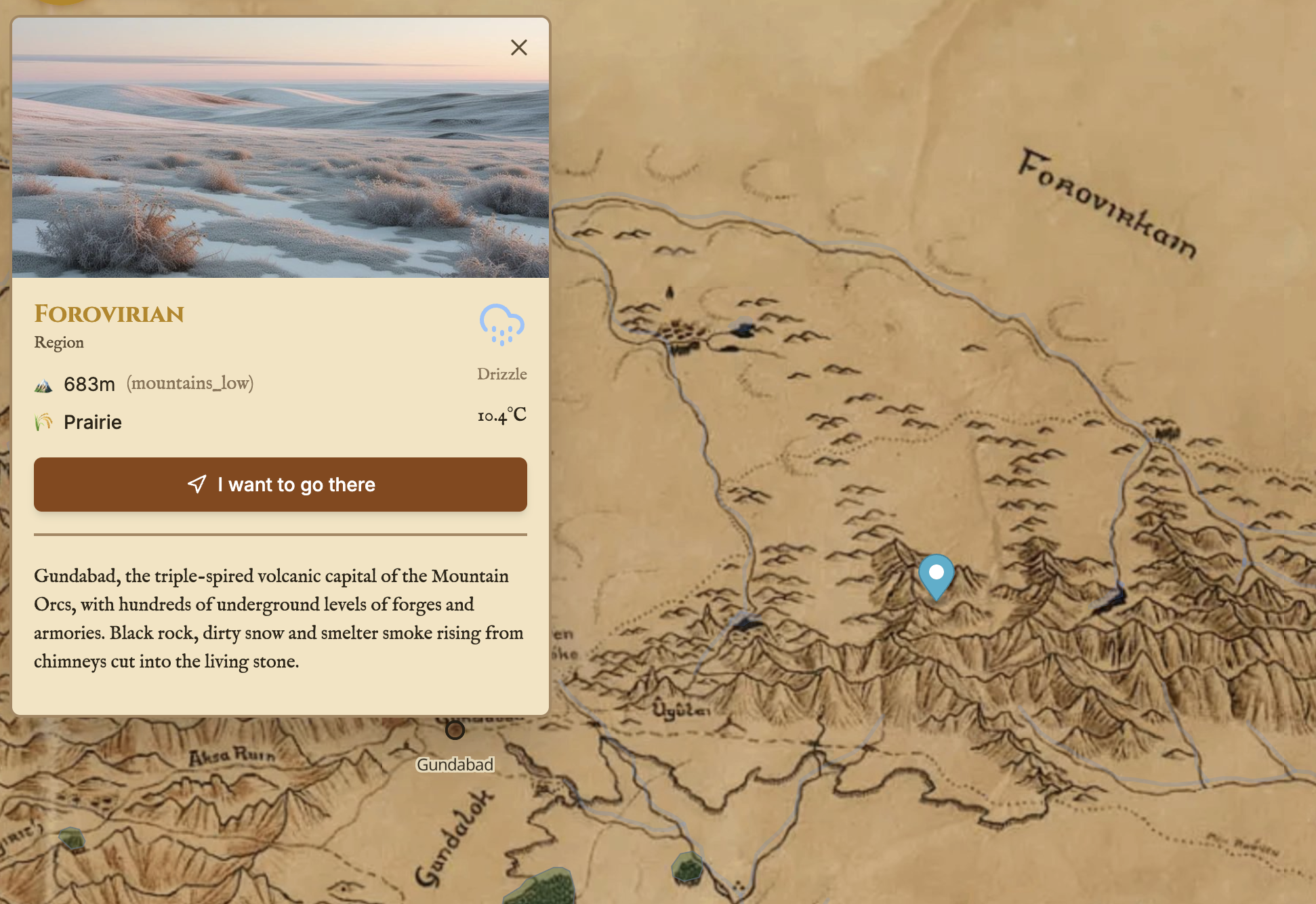
Why not just invent the weather
The easy way to give a fantasy map “weather” is to make it up. Roll some dice, pick “rainy”, move on. It works, but it feels empty, because invented weather has no memory. It never knows that the coast is milder than the interior, that mountains take the rain, that summer nights in the south stay warm.
Since the whole project is built on the idea that Middle-earth is georeferenced onto real European coordinates, I had a better option available: use real weather.
But which real weather? Modern data is contaminated: cities, highways, the urban heat-island effect, a century of industrial warming. None of that belongs in a world of villages and forests. So I went back to 1950: recent enough to have good hourly records, old enough to be before the boom. Not pre-industrial, but as close as I could get while still using real numbers.
The core idea: every region has a real-world twin
The whole system rests on one matching exercise. For every one of the 87 regions of Middle-earth, I picked a real European location whose climate feels like that region should feel, and stored it with its Köppen classification and real coordinates.
The Shire is the Cotswolds. Rohan is the Hungarian steppe. Lórien is the primeval Białowieża forest. Mordor is a dry volcanic corner of eastern Anatolia, which fits better than I expected.
Each region simply points at a climate_zone:
-- regions.climate_zone_id → climate_zones.id
-- climate_zones stores: koppen, analog_location, analog_lat, analog_lon,
--                       desc, temperature pattern, precipitation pattern
Then I downloaded a year and a half of history
For each of those analog locations I pulled hourly 1950 weather (ERA5 / Open-Meteo style) into the climate_data table: temperature at 2 m, relative humidity, precipitation, snowfall, cloud cover, wind speed and direction, surface pressure, soil moisture, evapotranspiration, shortwave radiation.
The result: 744,600 hourly climate rows. A full year, hour by hour, for every climate zone on the map.
The time-travel trick
This is the part I like most. When you look at the weather in-game “right now”, the system takes today’s date, keeps the month, day and hour, and swaps the year for 1950:
// today → the same moment in 1950
const now = new Date();
const month = String(now.getUTCMonth() + 1).padStart(2, '0');
const day   = String(now.getUTCDate()).padStart(2, '0');
const hour  = String(now.getUTCHours()).padStart(2, '0');
const timestamp1950 = `1950-${month}-${day} ${hour}:00:00`;
So if it’s a drizzly October afternoon where you’re sitting, it’s a drizzly October 1950 afternoon in the Shire too. The same mapping happens on the client (useGlobalClimateTime) and the backend, so the calendar, the map and the story all agree on what the sky is doing. You can also wind the calendar forward or backward to visit other seasons.
There is also a get_climate_at_point_with_transition() PostGIS function so that borders between climate zones blend instead of snapping. No hard line where temperate instantly becomes desert.
Every region and its real-world climate twin
This is the core of the system: the full matching list. Middle-earth on the left, the real 1950 weather source on the right.
| Middle-earth region | Köppen | Real-world analog | Coords (lat, lon) |
|---|---|---|---|
| Andrast | Cfb-coastal | Cape Finisterre, Galicia (Spain) | 42.88, -9.27 |
| Anfalas | Csa | Languedoc coast, Hérault (France) | 43.40, 3.70 |
| Angmar | Dfc | Jotunheimen valley (Norway) | 61.60, 9.00 |
| Anórien | Csa-Csb | Interior Umbria, Perugia (Italy) | 43.10, 12.39 |
| Bree | Cfb | Cotswolds, Gloucestershire (England) | 51.83, -1.82 |
| Central Misty Mountains | ET-mountain | Gotthard Pass (Switzerland) | 46.55, 8.57 |
| Dale | Dfb | Nowy Targ, Lesser Poland (Poland) | 49.48, 20.03 |
| Dol Guldur | Dfb | Polesie, Belarus/Ukraine border | 52.10, 27.50 |
| Dorwinion | BSk-Dfb | Sea of Azov coast (Ukraine) | 46.85, 38.00 |
| Eregion | Cfb | Eifel, Rhineland (Germany) | 50.37, 6.65 |
| Fangorn | Cfb-Dfb | Bayerischer Wald, Bavaria (Germany) | 49.05, 13.35 |
| Forochel | Dfc-cold | Finnmark coast (Norway) | 70.66, 25.10 |
| Harondor | BSh | Almería, Cabo de Gata (Spain) | 36.77, -2.19 |
| Iron Hills | Dfc | Chelyabinsk Oblast, Ural (Russia) | 54.70, 61.40 |
| Lórien | Cfb | Białowieża Forest (Poland) | 52.70, 23.86 |
| Mirkwood Wilds | Dfb | Bieszczady, Poland/Ukraine | 49.20, 22.50 |
| Mordor | BWh | Doğubayazıt, Eastern Anatolia (Turkey) | 39.55, 44.08 |
| North Misty Mountains | ET-mountain | Jotunheimen (Norway) | 61.60, 8.30 |
| Nurn | BSh-BSk | Lake Urmia basin, NW (Iran) | 37.50, 45.50 |
| Rivendell | Cfb-mountain | Engadine Valley (Switzerland) | 46.50, 9.83 |
| Rohan | Dfb | Hortobágy (Hungary) | 47.60, 21.00 |
| Talath Uichel | ET-Dfc | Inari, Lapland (Finland) | 68.90, 27.01 |
| The Shire | Cfb | Cotswolds, Gloucestershire (England) | 51.83, -1.82 |
| Woodland Realm | Dfb | Bieszczady Forest, Poland/Ukraine | 49.20, 22.50 |
(A representative slice of the full 87-region table.)
A few things jump out:
- Britain and Ireland cover most of the north. Arnor, Lindon and the Shire lean on the mild, wet Atlantic edge (
Cfb/Cfc), which gives the north of the map the damp, green weather it should have. - The south warms up sensibly. Gondor’s coasts borrow Mediterranean
Csa/Csbclimates from Italy, Spain and southern France. - Evil is dry. Mordor (
BWh, hot desert), Nurn and the eastern steppes reach as far as Turkey, Iran and the Ukrainian and Russian plains. The dangerous regions turned out to be the driest ones. - The far north is genuinely Arctic. Forochel and Talath Uichel pull from Norwegian and Finnish Lapland (
Dfc/ET), up past 68° latitude.
What this buys the story
Because the weather is real and seasonal, everything downstream inherits that realism for free:
- A journey in winter through the northern moors is cold and miserable because the data says so. I never had to write “it is cold here” anywhere.
- The AI narrator receives real temperature, precipitation and cloud for the exact day and place, so its descriptions of sky and mud are grounded, not generic.
- Travel cost can react to weather upstream of the route calculation.
Lessons from borrowing a year of weather
- Real data has memory, invented data doesn’t. Coasts stay mild, interiors swing, mountains are harsh, and I didn’t have to model any of it. 1950 had already done the work.
- The matching is the design work. The code is easy. Deciding that Rohan is Hungary and Mordor is eastern Anatolia is what gives the world its character.
- Blend the borders. Transition zones between climates were the difference between a map with regions and a world.
Next: with the ground and the sky in place, I had to let people travel across it, without accidentally routing them through Mordor. → Getting directions on Middle Earth (without passing through Mordor)